Nearly 800 major wildfires recorded in Europe in 2016
Davide Del Papa, Carlo Palermo
Last August 7, european satellite Sentinel–2 captured images of vast wildfire in Elba Island, Italy.
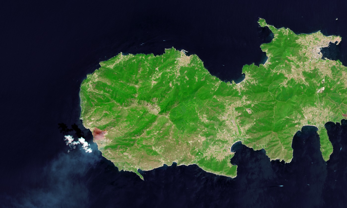
Contains modified Copernicus Sentinel data 2016 - composite: SWIR(12–8–4) + RGB(4–3–2).
Wildland fires in summer 2016
Wildfires by Country and Size Class¹:
| Unknow | Small | Medium | Large | Major | Total | |
|---|---|---|---|---|---|---|
| Italy | 87 | 47 | 63 | 10 | 8 | 215 |
| France | 7 | 49 | 46 | 11 | 6 | 119 |
| Turkey | 19 | 44 | 28 | 8 | 0 | 99 |
| Portugal | 84 | 1 | 1 | 4 | 3 | 93 |
| Greece | 49 | 9 | 16 | 4 | 5 | 83 |
| Bulgaria | 11 | 11 | 24 | 6 | 5 | 57 |
| Croatia | 5 | 5 | 9 | 3 | 0 | 22 |
| Sweden | 0 | 11 | 9 | 1 | 0 | 21 |
| Spain | 4 | 0 | 2 | 3 | 9 | 18 |
| Cyprus | 1 | 8 | 6 | 1 | 1 | 17 |
| Germany | 0 | 4 | 2 | 0 | 0 | 6 |
| Morocco | 1 | 0 | 3 | 2 | 0 | 6 |
| Algeria | 0 | 1 | 4 | 1 | 0 | 6 |
| Bosnia & Herzegovina | 1 | 1 | 1 | 0 | 1 | 4 |
| Slovenia | 1 | 0 | 2 | 1 | 0 | 4 |
| Romania | 1 | 0 | 1 | 1 | 0 | 3 |
| Austria | 0 | 1 | 2 | 0 | 0 | 3 |
| Estonia | 0 | 0 | 3 | 0 | 0 | 3 |
| Moldova | 0 | 0 | 2 | 0 | 0 | 2 |
| Slovakia | 0 | 0 | 2 | 0 | 0 | 2 |
| Tunisia | 0 | 1 | 1 | 0 | 0 | 2 |
| Israel | 2 | 0 | 0 | 0 | 0 | 2 |
| Jordan | 0 | 1 | 0 | 0 | 0 | 1 |
| Ukraine | 0 | 0 | 1 | 0 | 0 | 1 |
| Czech Republic | 0 | 0 | 1 | 0 | 0 | 1 |
| Total | 273 | 194 | 229 | 56 | 38 | 790 |
The European Forest Fire Information System, EFFIS, keeps a record for public service which stores data concerning the location, the class, and the extent of the fires that devastate the European green surface. Moreover other countries of Mediterranean area are also monitored.
Through Firenews service, we have news about 790 wildfires this year, in the period between April 1 and October 12.
The statistics concerning countries and type of fire that affects them show that while some states had a few major fires, which caused massive loss of green surface, other nations instead were affected by many small and medium fires scattered throughout the country’s surface.
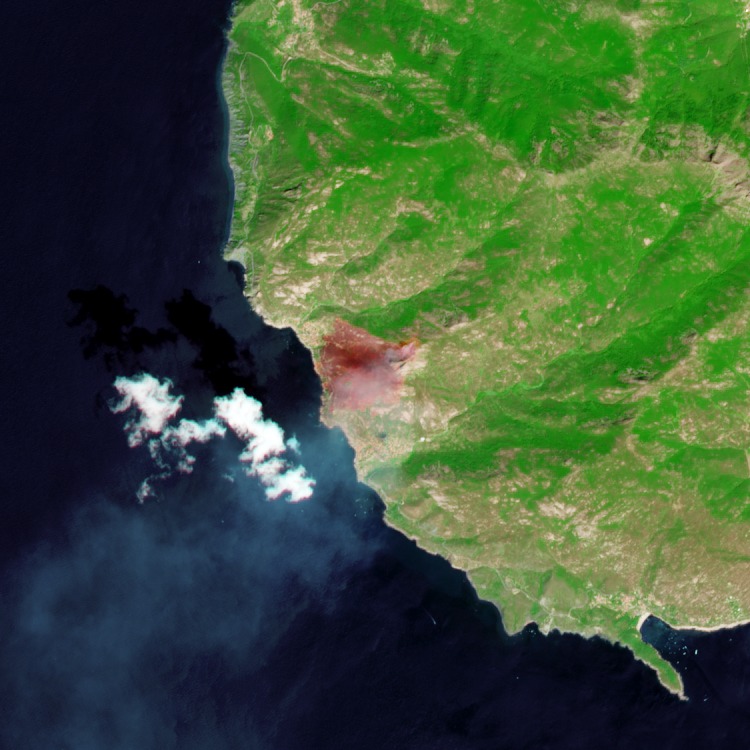 Elba Island, Italy, August 7 2016 - Contains modified Copernicus Sentinel data 2016
To understand this phenomenon, one should remember that any fire needs three things to occur: fuel, an oxidizing agent and sufficient heat. In a forest area surely the fuel is not lacking. The oxidizing agent too is not scarce at all: oxygen is abundantly released into the air by the trees during the day as an added dividend of the process of photosynthesis. In addition, during the course of the year there may be extra causes that favor a fire, some increasing the flammability of the fuel, others increasing the amount of oxygen in the air. In fact, during periods of drought the barks of the trees are more flammable, while the undergrowth can get completely dry sometimes, favoring fires just at the base of the trunks of the trees. A strong wind, or even the morning and evening breezes can facilitate the development of a forest fire by increasing air availability. The drafts also facilitate the spread of the flames. In fact, the fire that has reached the top of the trees tends to spread in an airborne way: hot embers and ashes tossed around by air currents can carry away burnt twigs and leaves, raining them on top of surrounding plants. Despite climatic conditions can promote the formation or the spread of a forest fire, one has to remember that the determining factor to trigger a fire lies in the way which heat is applied to the fuel. As a matter of fact, without sufficient heat provided in some way, the chain reaction needed for a fire would not start at all. In this department one should search for a culprit or a triggering cause for wildfires.
¹Size Class: burned Hectares
- Small: < 11
- Medium: 11 – 100
- Large: 101 – 500
- Major: > 500
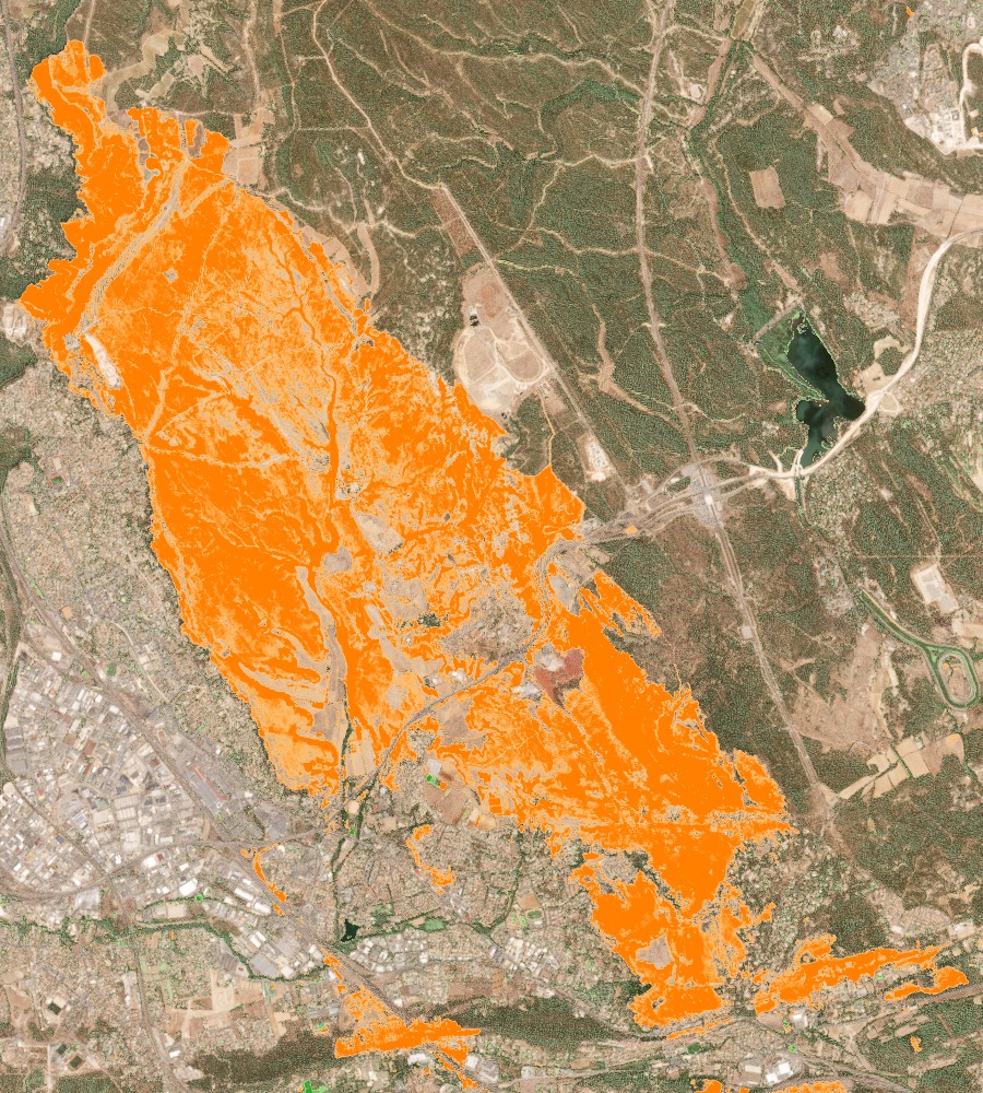
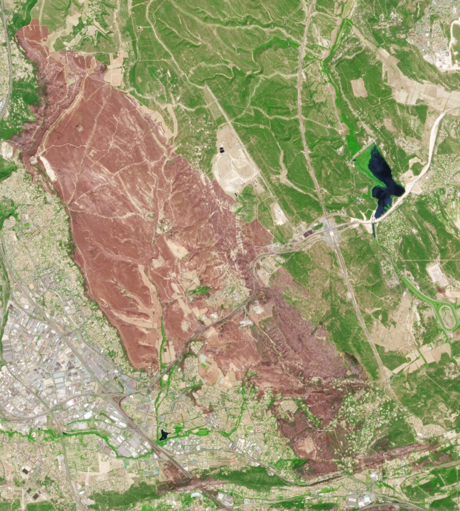
An Example: Forest Fires in Marseille, France
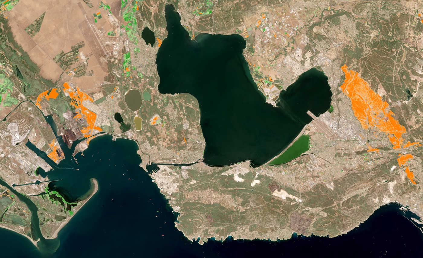 Contains modified Copernicus Sentinel data 2016 - composite: ( NDVI[2016/07/24] - NDVI[2016/08/13] ) + RGB(4–3–2)
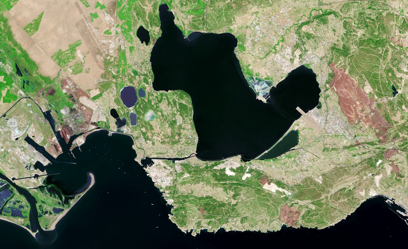 Contains modified Copernicus Sentinel data 2016 - composite: SWIR(12–8–4) + RGB(4–3–2)
Satellite images from the Sentinel–2 show forest fires that hit the inland area of Marseille the first days of August, in the department of Bouches-du-Rhône, in the southeast of France. The image was obtained by the difference between two NDVI images of the area. The fire, which broke out in Rognac and spread enough to get near the town of Vitrolles has destroyed 350 hectares of land, of which more than 250 were formations of the Mediterranean Maquis shrub-land. The fire has left also 33 people injured and 25 properties destroyed. The forest fire in Marseilles has been favored by the great drought that from the beginning of summer 2016 has affected especially the south of France. The French forestry department, following the EFFIS directives, uses a scale of 1 to 6 to classify the areas that present a possible risk of fire: by August 11th nine out of twelve areas comprising the department of Bouches-du-Rhône had been classified level 4, while the remaining 3 where classified level 5. Despite the high alert, a forest fire is always difficult to control; in fact, when there are favorable conditions the flames can spread inside a forest advancing even 20 or 30 meters per minute. The fire in the inland of Marseille was favored both by a period of prolonged drought and by a strong Mistral wind that blew almost till the gates of Marseille, with gusts reaching up to 100 km/h.
- lexpress.fr: Bouches-du-Rhône: trois incendies toujours en cours à Fos-sur-Mer
- nouvelobs.com: Incendies près de Marseille : pourquoi il est difficile de maîtriser un feu de forêt
The effects of one of the wildfires in the area of Marseille:
 Contains modified Copernicus Sentinel data 2016
 Contains modified Copernicus Sentinel data 2016